Nadiputra — Smart Public Bus Real-Time System
9 Public Transport Lines with Publicly Accessible Real-Time Tracking — IND-39 Compliant
Overview
Putrajaya’s Fully Real-Time Public Bus Network
All 9 public transport routes serving Putrajaya are equipped with publicly accessible real-time passenger information systems — achieving full compliance (100%) with MS ISO 37122:2019 Indicator 39. Commuters can access live bus positions, estimated arrival times, and route maps through three complementary digital platforms: the Nadiputra Rider App, MyRapid PULSE App, and the Rapid On-Demand App.
The 9 Public Transport Lines in Putrajaya
All routes below are publicly trackable in real time via Nadiputra Rider App or MyRapid PULSE.
Nadiputra Bus Routes (7 Lines)
| No. | Route | Description |
|---|---|---|
| 1 | Laluan P101 | Kompleks F – Persiaran Perdana – MOTAC, Presint 5 |
| 2 | Laluan P102 | Kompleks E – Presint 11 |
| 3 | Laluan P103 | Kompleks E – Alamanda – Presint 15 |
| 4 | Laluan P104 | Dataran Gemilang – MOTAC, Presint 5 |
| 5 | Laluan P105 | Dataran Gemilang – Kompleks E |
| 6 | Laluan P106 | Kompleks E – Presint 4 |
| 7 | Laluan P108 | Terminal Putrajaya Sentral – Kompleks E |
RapidKL MRT Feeder Routes (2 Lines)
| No. | Route | Description |
|---|---|---|
| 8 | Laluan T509 | Terminal Putrajaya Sentral – Presint 16 / Alamanda |
| 9 | Laluan T511 | Terminal Putrajaya Sentral – Presint 4 / Dataran Gemilang |
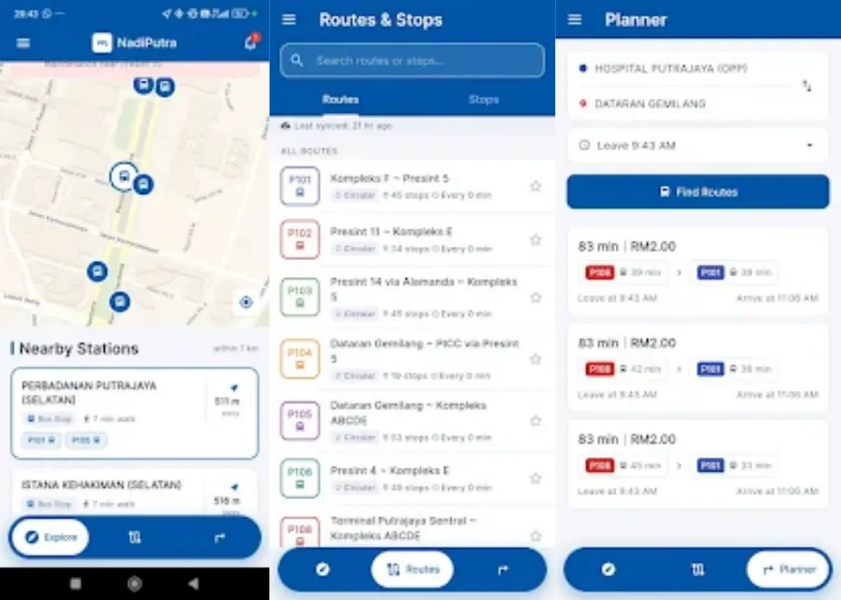
Platform 1: Nadiputra Rider App
nadiputra.ppj.gov.my is Perbadanan Putrajaya’s (PPJ) official public bus tracking application — available on iOS and Android. It provides:
- Live Bus Map: Real-time GPS positions of all active Nadiputra buses on an interactive map
- Route Information: Full route paths, stop sequences, and schedules for P101–P108
- Bus Stop Finder: “Nearby Stops” feature locating the nearest bus stop within the user’s vicinity
- Service Updates: Push notifications for service disruptions, route changes, and special event schedules
- ETA Display: Estimated arrival time for the next bus at each stop (e.g., “P101 · 23 min”, “P109 · 13 min”)
The Nadiputra app architecture is built on a GTFS Realtime feed engine, enabling integration directly into Google Maps — so commuters can plan Putrajaya bus journeys without leaving the Maps interface.
Platform 2: MyRapid PULSE App (Prasarana)
The MyRapid PULSE app (by Prasarana Malaysia Berhad) covers the MRT feeder routes T509 and T511 connecting Putrajaya Sentral with major precincts:
- Real-time Bus Tracker: Live position of RapidKL feeder buses serving Putrajaya
- Journey Planner: Integrated planning from any origin to Putrajaya via MRT + bus connections
- Rapid Mesra / Rapid Pelajar Integration: Concessionary card validation linked to real-time journey data
- Cashless Payment: TNG Card, e-Wallet (Touch ‘n Go, Boost, Shopee, Grab), DuitNow QR, Rapid Emas
Platform 3: Rapid On-Demand (Demand-Responsive Transit)
The Rapid On-Demand service provides flexible, app-booked van transit across defined Putrajaya zones:
| Zone | Coverage |
|---|---|
| T512B | MRT Putrajaya Sentral – Presint 11 |
| T513B | MRT Putrajaya Sentral – Presint 14 & 16 |
| T514B | MRT Putrajaya Sentral – Presint 11 – Dengkil |
Features:
- App-based booking: Select pick-up and drop-off points on map
- Demand-responsive: Vehicle dispatched only when booking confirmed — no fixed schedule
- Vehicle type: Standard Van
- Operating hours: 6:00 AM to 11:30 PM, Monday to Sunday
- Cashless payment: Full suite of Rapid payment methods (TNG, e-Wallet, DuitNow, debit/credit)
Strategic Alignment
| Framework | Alignment |
|---|---|
| MSCF Component | Smart Mobility — Public Transportation Real-Time System (K4) |
| PSCB Thrust | Thrust 1: Smart Transportation & Mobility (1.4 Transit information, 1.5 On-demand mobility) |
| RPP2050 Polisi | P5: Rangkaian Mobiliti Bandar Bersepadu; P6: Ekosistem Mobiliti Aktif Inklusif |
| MS ISO 37122:2019 | IND-39 (K4) — 100% (9/9 lines with real-time systems) |
| SDG Targets | SDG 11.2 (Accessible transport for all); SDG 13.1 (Climate resilience) |
| IOC Integration | Fleet telemetry monitored at Putrajaya Command Centre (PCC) |
| Data Protection | PDPA-compliant; location data processed anonymously for transit optimization |
Fleet Monitoring at Putrajaya Command Centre
All active Nadiputra buses transmit continuous GPS telemetry to the Putrajaya Command Centre (PCC) via the Putranet private network, enabling:
- Real-time headway management between buses on high-frequency routes
- Automated alerts for schedule deviations (>5 minutes late)
- Speed compliance monitoring and driver safety analytics
- Fleet availability dashboard for operations scheduling
Key Highlights
Technology Stack